The Newbridge Park + Ride stands to benefit from an improved public transport service to the City Centre.
The existing bus service is adequate for the current P+R facilities, but it is clear that the small size of this site is suppressing a much larger demand than can at present be accommodated. There are plans to increase the capacity of the site but this would soon overwhelm the existing bus service with a very large demand at peak periods, falling off to one which was uneconomic throughout much of the day.
An apparently easy option would be to increase the number of buses serving the site. This could add to the city's congestion problems because certain parts of the present road routes are congested and there is limited space available for setting-down and picking-up passengers in the City Centre . Furthermore there would be no economies of scale or improvements in loading patterns to be gained by this approach.
Other solutions have been sought:
BUSWAY PROPOSALS
A bus-based 'Rapid Transit' system, utilising the old Midland Railway alignment, has been proposed; but this would suffer from a number of serious disadvanteges:
TRAMWAY PROPOSALS
The route between Newbridge and the City Centre should be considered in two parts. An off-road Western Riverside alignment which will by-pass congested inner-city roads; and the Western Riverside to Newbridge alignment, part of which can run on the wide and relatively uncongested Newbridge Road. A number of advantages would accrue from operating on these alignments and from using trams:
OPTIMISING THE CHANGEOVER POINT
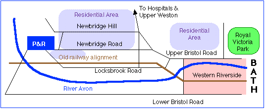
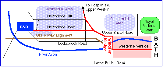
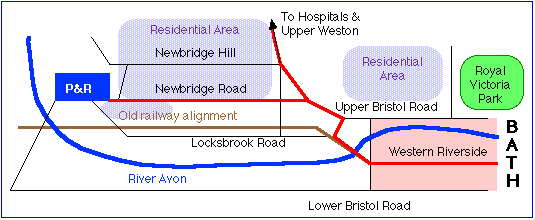
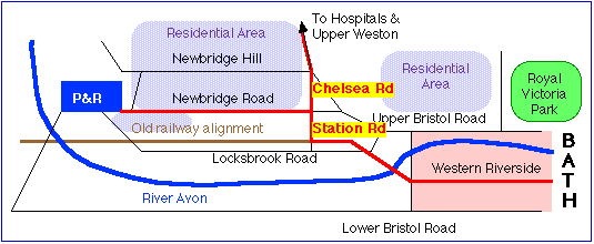
The choice of changeover point from reserved track on the Western Riverside to street track on Newbridge Road will mainly be influenced by the balance between avoidance of traffic congestion and optimising accessibility for passengers.
|
|
|
 |
|
|
|
|
|
Catchment area (500 metres walking distance) includes Audley Park Road and theTennyson Road - St.Johns Road area, which has high housing density. |
Would require considerable traffic management at northern end of Windsor Bridge to allow trams priority over queueing traffic |
|
Serves play area of Royal Victora Park. |
May need extra road space in Windsor Bridge Road |
|
Could use existing Windsor Bridge |
Bridge structure was not designed for trams, some additional engineering work may be needed. |
|
|
|
|
|
|
 |
|
|
|
|
|
Avoids a short sometimes-congested stretch of Upper Bristol Road between Windsor Bridge Road and Locksbrook Road |
Traffic management measures would still be needed on some of the Upper Bristol Road and additional measures would be needed at the junction between this and Locksbrook Road |
|
Could use existing railway bridge to cross river without additional engineering work |
Old railway bridge could become a liability when repairs are needed. |
|
Better access to part of Locksbrook Road |
Does not serve Royal Victoia Park or Park Lane and is a greater distance from the Audley Park Road area |
|
|
|
 |
|
|
|
|
|
Avoids a long stretch of the Upper Bristol Road and Newbridge Roads between Windsor Bridge Road and Chelsea Road |
The junction between Station Road and Newbridge Road is very restricted in space and has an adverse camber. Construction of a satisfactory alignment could necessitate demolition of some surrounding properties (which TfB would not advocate) |
|
Could use existing railway bridge to cross river without additional engineering work |
Old railway bridge could become a liability when repairs are needed. |
|
Better access to some of Locksbrook Road |
Does not serve Royal Victoria Park, Audley Park Road or theTennyson Road - St.Johns Road area |
|
|
|
 |
|
|
|
|
|
Avoids Newbridge Road and Upper Bristol Road entirely |
Difficult of access |
|
Dedicated fast service |
Hospitals/Upper Weston Route would need to be constructed separately |
|
Uninterrupted by stops |
Does not serve large areas of Lower Weston, Newbridge Hill area - would run almost empty for much of the day. |
|
Could use existing railway alignment |
Parts of this alignment may need reconstruction and could become a maintenance liability |
|
|
Railway alignment may be needed in future for long-distance transport link |
For further information see:
B&NES "Rapid Transit"
proposal for Western Riverside
Western Riverside Route
Upper Weston and Newbridge
routes
Guided busway
Western Riverside
reports
Guide to prospective
developers
City Centre Circle
Interchange
Segregation of
tramways
Speed of boarding with
conductors
Peak
demand
Pollution